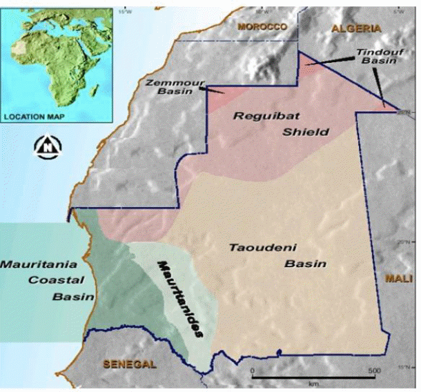
The aim of this article is to present the current status of exploration in the Islamic Republic of Mauritania and to highlight the petroleum potential of the virtually unexplored onshore Mauritanian basins. 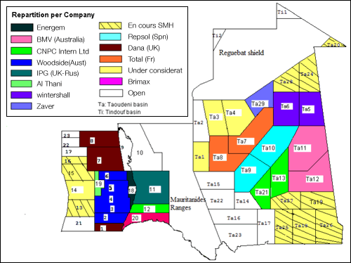 A regional Petroleum evaluation of the petroleum potential of the Mauritanian basins (Coastal and Taoudeni basins) was carried out by BEICIP-FRANLAB in 1980. A second evaluation of the coastal basin was carried out in 1985. The two studies were performed for the Ministry of Mines and Industry with World Bank financing. The information given below is taken from these studies updated with the results of exploration performed between 1985 and 2001, and is complemented by information of the legal and contractual framework. Mauritania comprises 4 large geographical/geological units: The intracratonic Taoudeni basin covering half of the country and opening eastward into Mali, the coastal basin straddling the coastline and extending southward over Senegal, the Reguibat Shield with Precambrian and basement outcrops, the Mauritanides Range, severely eroded, between the two basins:
The Mauritania Coastal Basin
The coastal basin extends from the northern to southern borders of the Mauritanian coastline over a distance of some 500 kilometres, and is over 300 kilometres wide from east to west. The coastal basin covers more than 160,000 km2, with 100,000 km2 of the basin being offshore.
DISCOVERIES
- Chinguetti(2001), Zone B
- Banda (2002), Zone A
- Walata (2003), Zone B
- Pélican (2003), C7
- Tevet (2004), Zone B
- Labeidna (2005), Zone B
- Aigrette (2006), C7
- Ahmeyim (Ex-Tortue) (2015), C8
- Bir Allah (Ex-Marsouin) (2015), C8
Exploration History
Exploration began in the coastal basin in 1960. Since then, only 40 wells have been drilled, all between 1968 until now. Table 1 details the exploration history. The seismic acquisition history is outlined in Table 2, and the drilling history in Table 3.
Exploration has been steady, albeit slow, since 1966, with a brief period of non-exploration between 1992 and 1997. Most exploration has been focussed on the outer shelf, with one near shore well, and three deepwater wells.
Seismic Surveys
Offshore, the seismic grid is dense between the coast and the 2000 metre bathymetric contour. Conversely, onshore coverage is sparse, comprising only two reconnaissance surveys totalling only 1005 kilometres in the southern part of the country.
A total of 69,000 kilometres of 2D data and more than 1 8,500 km2 of 3D data have been acquired offshore since 1966. The quality of modern seismic data is generally quite good, with the recent Woodside JV acquired data (10,500 kilometres of 2D data and approximately 6000 sqkm of 3D data) highlighting the potential data quality that can be achieved offshore. In 2001, Veritas obtained the first speculative seismic acquisition survey of approximately 4333km 2D.
A database of most of this seismic data is available from the Department of Mines & Geology, including reprocessed lines from several of 1980’s vintage surveys. This includes some 30,000 kilometres of seismic lines and associated location maps. The data acquired by the Woodside JV is currently confidential and is hence unavailable.
Mauritanian government has signed an agreement on june , 2003 , with TOTAL allowing him to proceed prospecting for oil in the Taoudeni Basin (onshore)in Mauritanian desert.
Seven different operators have acquired 24 wells distributed unevenly throughout the offshore sector. Most wells targeted the CretaceousøTertiary post rift section. The deepest stratigraphic test is the Loup de Mer-1 well: the Neocomian carbonate bank being the primary objective. Most of the remaining wells targeted CretaceousøTertiary sandstone reservoirs. The syn-rift and early post-rift section remains untested in the coastal basin.
Four 7 of the 17 wells, six failed due to lack of reservoir, with the objectives being in a midøupper slope setting. Most were drilled before the modern understanding of deepwater depositional systems. Nonetheless, V-1 recovered some seven litres of oil from thin Maastrichtian sandstones, while significant shows were also recorded from the nearby Coppolani-1 well.
of the thirteen wells intersected extremely sand-prone systems with trap integrity posing the greatest reason for failure. Autruche-1 was probably drilled too far down-dip from the bounding fault in a tilted fault block, although attic reserves are likely to be marginal at best. All four wells recorded oil shows. Ras el Baida-1 targeted a deepwater Senonian fan delta, and recorded oil shows. The fan delta was extremely sand-prone.
( Table ref : Exploration History of the Mauritania Coastal Basin )
There are several recorded hydrocarbon shows in offshore of Mauritania.
Most important of these are the discovery of Chinguetti-1 and the V-1 oil recovery from thin Mauritanian deepwater sands.
The V-1 well also intersected an early oil mature Turonian source interval from 3500m.
Coppolani-1 recovered oil during circulation whilst drilling the Maastrichtian–Campanian, but there were no economically important reservoirs at this level.
OCT-1B also recorded oil shows through the Late Cretaceous.
V-1, OCT-1B and Coppolani-1 may have been charged from Cretaceous marine source rocks.
Autruche-1 recovered oil shows from the Aptian–Albian, including an interpreted hydrocarbon column in well logs.
There does there not appear to be any Mid-Cretaceous marine source rocks in the Autruche-1 area.
An alternative source may exist in the Jurassic or Early Cretaceous.
Ras el Baida-1 also recorded oil shows from the Lower Tertiary. The origin of these oils is unknown.
The oil production in the country started in 2006 .
Seismic Acquisition History of the Mauritania Coastal Basin Download
Drilling history of the Mauritania Coastal Basin Download